

-
About Upazilla
Upazila Identity
History-Tradition
Geographical and Economic
Others
-
Upazilla Porishad
About Upazilla Porishad
বার্ষিক উন্নয়ন পরিকল্পনা(এডিপি)
পঞ্চবার্ষিকী পরিকল্পনা
উপজেলা পরিষদ আর্থিক প্রতিবেদন
উপজেলা কমিটির সভার কার্যবিবরনী
-
আইন শৃঙ্খলা সংক্রান্ত কমিটি
-
যোগাযোগ এবং ভৌত অবকাঠামো উন্নয়ন
-
কৃষি ও সেচ বিষয়ক কমিটি
-
মাধ্যমিক ও মাদ্রাসা শিক্ষা বিষয়ক স্থায়ী কমিটি
-
প্রাথমিক ও গণশিক্ষা বিষয়ক কমিটি
-
স্বাস্থ্য ও পরিবার কল্যাণ কমিটি
-
যুব ও ক্রীড়া উন্নয়ন কমিটি
-
নারী ও শিশু উন্নয়ন কমিটি
-
সমাজ সেবা কমিটি
-
মৎস্য ও প্রাণিসম্পদ বিষয়ক কমিটি
-
মুক্তিযোদ্ধা বিষয়ক কমিটি
-
পল্লী উন্নয়ন ও সমবায় কমিটি
-
সংস্কৃতি বিষয়ক কমিটি
-
বন ও পরিবেশ বিষয়ক কমিটি
-
বাজার মূল্য পর্যবেক্ষণ, মনিটরিং এবং নিয়ন্ত্রন কমিটির
-
অর্থ, বাজেট ও পরিকল্পনা এবং স্থানীয় সম্পদ আহরণ কমিটি
-
জনস্বাস্থ্য, স্যানিটেশন এবং বিশুদ্ধ পানীয় জল সরবরাহ কমিটি
আর্থিক বিবরণী
তথ্য প্রদানকারী কর্মকর্তা
-
আইন শৃঙ্খলা সংক্রান্ত কমিটি
-
Administration
Organization Related
Schedule and meeting
Service & Other
- Municipality
-
Govt. Offices
Education related
Agriculture and food related
Engineering & Information Technology
About Human Resources Development
Land Related
-
Other organizations
Educational Institution
Private Institute
National Law help
-
E-Service
National E-Service
Mobile App
- Gallery
- Social safety net
মেনু নির্বাচন করুন
-
About Upazilla
Upazila Identity
History-Tradition
Geographical and Economic
Others
-
Upazilla Porishad
About Upazilla Porishad
বার্ষিক উন্নয়ন পরিকল্পনা(এডিপি)
পঞ্চবার্ষিকী পরিকল্পনা
উপজেলা পরিষদ আর্থিক প্রতিবেদন
উপজেলা কমিটির সভার কার্যবিবরনী
- আইন শৃঙ্খলা সংক্রান্ত কমিটি
- যোগাযোগ এবং ভৌত অবকাঠামো উন্নয়ন
- কৃষি ও সেচ বিষয়ক কমিটি
- মাধ্যমিক ও মাদ্রাসা শিক্ষা বিষয়ক স্থায়ী কমিটি
- প্রাথমিক ও গণশিক্ষা বিষয়ক কমিটি
- স্বাস্থ্য ও পরিবার কল্যাণ কমিটি
- যুব ও ক্রীড়া উন্নয়ন কমিটি
- নারী ও শিশু উন্নয়ন কমিটি
- সমাজ সেবা কমিটি
- মৎস্য ও প্রাণিসম্পদ বিষয়ক কমিটি
- মুক্তিযোদ্ধা বিষয়ক কমিটি
- পল্লী উন্নয়ন ও সমবায় কমিটি
- সংস্কৃতি বিষয়ক কমিটি
- বন ও পরিবেশ বিষয়ক কমিটি
- বাজার মূল্য পর্যবেক্ষণ, মনিটরিং এবং নিয়ন্ত্রন কমিটির
- অর্থ, বাজেট ও পরিকল্পনা এবং স্থানীয় সম্পদ আহরণ কমিটি
- জনস্বাস্থ্য, স্যানিটেশন এবং বিশুদ্ধ পানীয় জল সরবরাহ কমিটি
আর্থিক বিবরণী
তথ্য প্রদানকারী কর্মকর্তা
-
Administration
Organization Related
Schedule and meeting
Service & Other
- Municipality
-
Govt. Offices
Education related
Agriculture and food related
Engineering & Information Technology
About Human Resources Development
Land Related
-
Other organizations
Educational Institution
Private Institute
National Law help
-
E-Service
National E-Service
Mobile App
- Gallery
- Social safety net
Main Comtent Skiped
Geographic contract
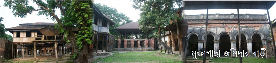
Identity: Muktagacha is an upazila in Mymensingh district of Bangladesh. Muktagacha is located in the west of Mymensingh district.Famous of the Muktagacha Monda. Muktagacha this Manda is not only Bangladesh but is famous for the world.In the nineteenth century zamindars made special contribution to the development of the city of Mymensingh.They built many palaces at different times, which still survive. Location, Area & Population: Muktagachha Upazila is just 16 kilometers away from Mymensingh city. The upazila consists of 24 ° 36'-24 ° 52' north latitudes and 90 ° 04'-90 ° 20' east longitudes. Total area of the upazila: 314.70 sq km. The number of unions 10 and municipalities in this upazila is 1. According to the 2011 census report, the total population of the upazila was 3,66,397. Among them male: 1,85,909 people and women: 1,80,488 Border: Mymensingh Sadar and Jamalpur Sadar upazilas on the north, Phulbari upazila on the south, Mymensingh sadar and Phulbari upazilas on the east, Madhupur and Jamalpur sadar upazilas on the west.


Site was last updated:
2025-06-23 11:34:41
Planning and Implementation: Cabinet Division, A2I, BCC, DoICT and BASIS
Technical Assistance:
![]()
Developed By: